tucson.social
  • Communities
  • Create Post
  • Create Community
  • heart
    Support Lemmy
  • search
    Search
  • Login
  • Sign Up
fossilesque@mander.xyzM to Science Memes@mander.xyzEnglish · 2 years ago

Dank projection, bro.

mander.xyz

message-square
66
link
fedilink
444

Dank projection, bro.

mander.xyz

fossilesque@mander.xyzM to Science Memes@mander.xyzEnglish · 2 years ago
message-square
66
link
fedilink
alert-triangle
You must log in or # to comment.
  • disguy_ovahea@lemmy.world
    link
    fedilink
    English
    arrow-up
    109
    ·
    2 years ago

    It’s also the only continent without a southern coast.

    • veroxii@aussie.zone
      link
      fedilink
      English
      arrow-up
      34
      ·
      2 years ago

      For now. It used to a few million years ago and will again in another few million.

      • disguy_ovahea@lemmy.world
        link
        fedilink
        English
        arrow-up
        24
        ·
        edit-2
        2 years ago

        Are you referring to the magnetic pole switch? That happens every 200-1M years, according to patterns on the seafloor. It’s been estimated that the last reversal was 780,000 years ago, so it theoretically could be any day now.

        With that being said, I doubt that humanity will agree to turn all maps 180° to correspond.

        • fogstormberry@lemmy.blahaj.zone
          link
          fedilink
          English
          arrow-up
          15
          ·
          2 years ago

          the continental plate also migrates

          • disguy_ovahea@lemmy.world
            link
            fedilink
            English
            arrow-up
            4
            ·
            edit-2
            2 years ago

            At the rate of 1 CM/year

            • fogstormberry@lemmy.blahaj.zone
              link
              fedilink
              English
              arrow-up
              1
              arrow-down
              2
              ·
              2 years ago

              deleted by creator

              • disguy_ovahea@lemmy.world
                link
                fedilink
                English
                arrow-up
                3
                ·
                2 years ago

                To move a continent north of the equator at the rate of 1 CM per year? You might need a bigger napkin.

                Antarctica’s leading coast is 10,000 KM from the equator. Assuming it’s able to continue through Southern Africa at the same rate, it would take 100 billion years to have a northern coast.

                • fogstormberry@lemmy.blahaj.zone
                  link
                  fedilink
                  English
                  arrow-up
                  5
                  ·
                  2 years ago

                  southern or northern coast. I had deleted my comment already because I misread yours, but I had mathed the time to move away from the pole, producing a southern coast. not time to cross the equator

        • veroxii@aussie.zone
          link
          fedilink
          English
          arrow-up
          11
          ·
          2 years ago

          I was referring to continental drift. Places move a lot in under 200 million years. Eg https://youtu.be/uLahVJNnoZ4

          So my post was a bit sarcastic that eventually it will have a coast but not on any time frame to matter to the human species. :)

        • fossilesque@mander.xyzOPM
          link
          fedilink
          English
          arrow-up
          3
          ·
          2 years ago

          Laschamp event! I just edited a related wiki page on late Pleistocene extinctions. Spoiler alert: it didn’t kill the megafauna.

        • swab148@startrek.website
          link
          fedilink
          English
          arrow-up
          2
          ·
          2 years ago

          Just flip it over lol

        • pacmondo@sh.itjust.works
          link
          fedilink
          English
          arrow-up
          0
          ·
          2 years ago

          I thought they were referring to the fact that under the ice its an archipelago, so if the ice melts it will have southern coasts again

          • fishos@lemmy.world
            link
            fedilink
            English
            arrow-up
            0
            ·
            2 years ago

            If it melts, they’d all be northern coasts.

            It’s referencing the pole swap.

    • orphiebaby@lemm.ee
      link
      fedilink
      English
      arrow-up
      9
      ·
      edit-2
      2 years ago

      Yeah, because you’ll fall off the bottom into space

  • Dasnap@lemmy.world
    link
    fedilink
    English
    arrow-up
    28
    ·
    2 years ago

    Long Earth theory.

  • Steal Wool@lemm.ee
    link
    fedilink
    English
    arrow-up
    29
    arrow-down
    1
    ·
    2 years ago

    How am I supposed to know how big that is? I don’t see a banana anywhere…

    • supercriticalcheese@lemmy.world
      link
      fedilink
      English
      arrow-up
      3
      ·
      2 years ago

      it’s too cold steel wool they don’t have bananas

    • KillingTimeItself@lemmy.dbzer0.comBanned
      link
      fedilink
      English
      arrow-up
      2
      ·
      2 years ago

      because it’s smaller than a pixel :)

      • Ignotum@lemmy.world
        link
        fedilink
        English
        arrow-up
        4
        ·
        2 years ago

        I yeah i see it now, it’s the pixel in the bottom right corner

        it’s 3% more banana-colored than the surrounding pixels, you can’t miss it

        • KillingTimeItself@lemmy.dbzer0.comBanned
          link
          fedilink
          English
          arrow-up
          2
          ·
          2 years ago

          there ya go.

  • GBU_28@lemm.ee
    link
    fedilink
    English
    arrow-up
    26
    ·
    2 years ago

    Where Saddam

  • Kalothar@lemmy.ca
    link
    fedilink
    English
    arrow-up
    21
    arrow-down
    1
    ·
    2 years ago

    Uh, antartica is about as wide as the U.S. and about as tall as it is wide.

    So, I just feel like I’m being bamboozled here

    • disguy_ovahea@lemmy.world
      link
      fedilink
      English
      arrow-up
      21
      arrow-down
      1
      ·
      edit-2
      2 years ago

      Mercator maps are lies.

      https://www.thetruesize.com/#?borders=1~!MTY2MDE2NDA.NDc5Njc5Nw*MjE1MTM3Mjc(MzM1MDIwMDg~!AQ*MTczNjE5MDg.MTI2ODc2MjY)MA

      • Kalothar@lemmy.ca
        link
        fedilink
        English
        arrow-up
        20
        arrow-down
        1
        ·
        2 years ago

        Yeah, they certainly are:

        • disguy_ovahea@lemmy.world
          link
          fedilink
          English
          arrow-up
          20
          arrow-down
          1
          ·
          edit-2
          2 years ago

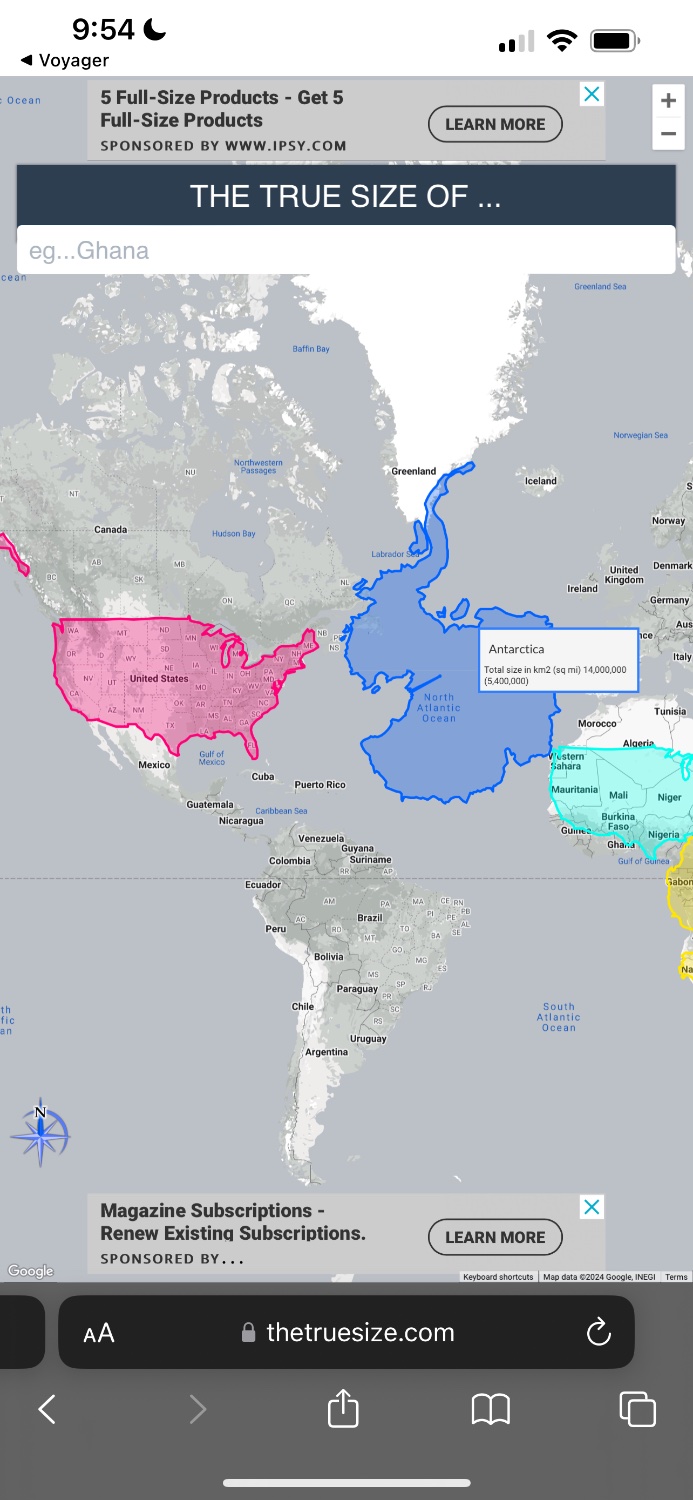
          That is inaccurate. The correct way to use the tool is to lay the continent over the US. It skews the size and scale appropriately in order to provide an accurate measurement.

          Antarctica vs US

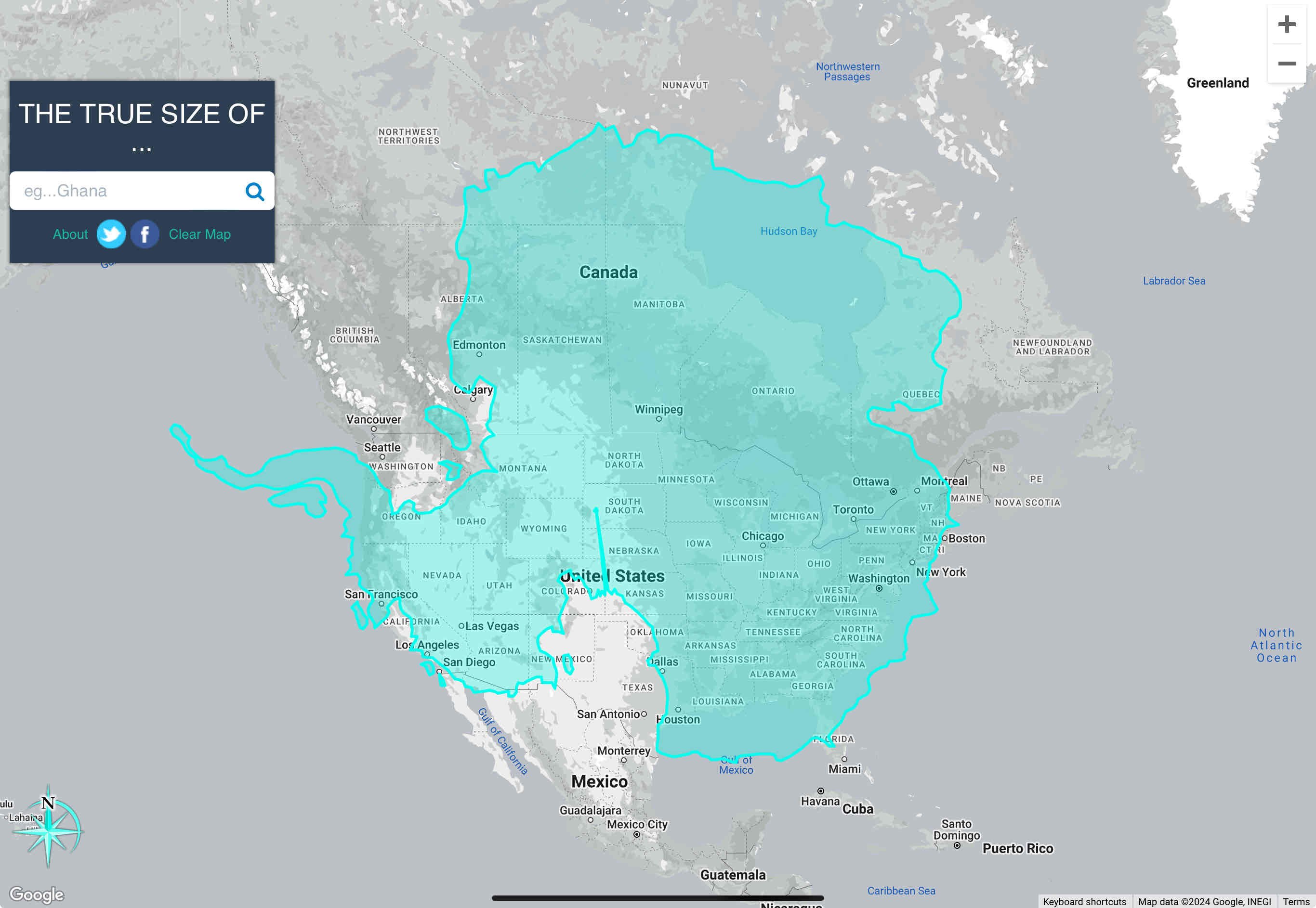
          It’s also larger in area than the US, including Alaska and all territories.

          The total area of the US and its territories is just over 3.8 million square miles. Antarctica’s area of 5.4 million square miles makes it 1.5x the size of the US.

          • NeatNit@discuss.tchncs.de
            link
            fedilink
            English
            arrow-up
            10
            arrow-down
            1
            ·
            2 years ago

            The correct way to use the tool is to lay the continent over the US.

            Typical American, declaring that the US is the default country to compare every other country to!

            On a more serious note, putting things side by side is the same as putting them over each other. Difference in height are not the same though, as closer to the equator size shrinks. The best way to compare is take two things and put them side by side on the equator - that’s where there’s least distortion.

            • disguy_ovahea@lemmy.world
              link
              fedilink
              English
              arrow-up
              1
              arrow-down
              2
              ·
              edit-2
              2 years ago

              How very nationalist of you to assume America-centrism where it is completely irrelevant. The comparison that was in dispute was the size of Antarctica vs the size of the US. I was clarifying how to use the tool. You’re still using it wrong, and now you’re being a tool. lol

              • NeatNit@discuss.tchncs.de
                link
                fedilink
                English
                arrow-up
                5
                arrow-down
                1
                ·
                2 years ago

                First sentence was a joke - hence “on a more serious note” for the next sentence. And if you think I’m using it wrong then, well, best of luck to you.

                • disguy_ovahea@lemmy.world
                  link
                  fedilink
                  English
                  arrow-up
                  1
                  arrow-down
                  1
                  ·
                  2 years ago

                  Why do you think the static grey map is in the background? The entire point of the tool is to overlay one nation upon one of the nations on the static map for accurate size comparison. It’s demonstrated clearly in the pop-up instructional video displayed when you first open the website.

      • SkybreakerEngineer@lemmy.world
        link
        fedilink
        English
        arrow-up
        2
        ·
        2 years ago

        Join the Organization of Cartographers for Social Equality today!

      • jonasw@discuss.tchncs.de
        link
        fedilink
        English
        arrow-up
        2
        arrow-down
        1
        ·
        2 years ago

        Kalothar is right

        https://www.thetruesize.com/#?borders=1~!MTY4NDk1MDM.NTE5OTU2*MTc5NjM3NzY(MjAyMDQxNw~!CONTIGUOUS_US*MTMzNTM3.MTE1MDkwMTA)MA~!AQ*MTY1OTExMjU.MTE1NjAxMjQ)MQ

    • realitista@lemm.ee
      link
      fedilink
      English
      arrow-up
      5
      ·
      2 years ago

      Just look at the map, what more proof do you need?

    • cobra89@beehaw.org
      link
      fedilink
      English
      arrow-up
      3
      ·
      2 years ago

      Yeah it’s definitely not a real projection. If Antarctica looked like that (taken top down) then the rest of the continents would not be oriented like that.

  • KillingTimeItself@lemmy.dbzer0.comBanned
    link
    fedilink
    English
    arrow-up
    14
    ·
    2 years ago

    and we certainly wont be in a few hundred years lmao.

  • workerONE@lemmy.world
    link
    fedilink
    English
    arrow-up
    13
    ·
    2 years ago

    Big if true

  • Diplomjodler@lemmy.world
    link
    fedilink
    English
    arrow-up
    11
    ·
    2 years ago

    Wait what? Did we just find Hitler’s secret Antarctica base?

    • disguy_ovahea@lemmy.world
      link
      fedilink
      English
      arrow-up
      12
      ·
      2 years ago

      That’s the Amundsen–Scott South Pole Station.

      • Diplomjodler@lemmy.world
        link
        fedilink
        English
        arrow-up
        15
        ·
        2 years ago

        Nonsense! Did you see how big that thing is? Definitely Hitler!

    • Refurbished Refurbisher@lemmy.sdf.org
      link
      fedilink
      English
      arrow-up
      8
      ·
      2 years ago

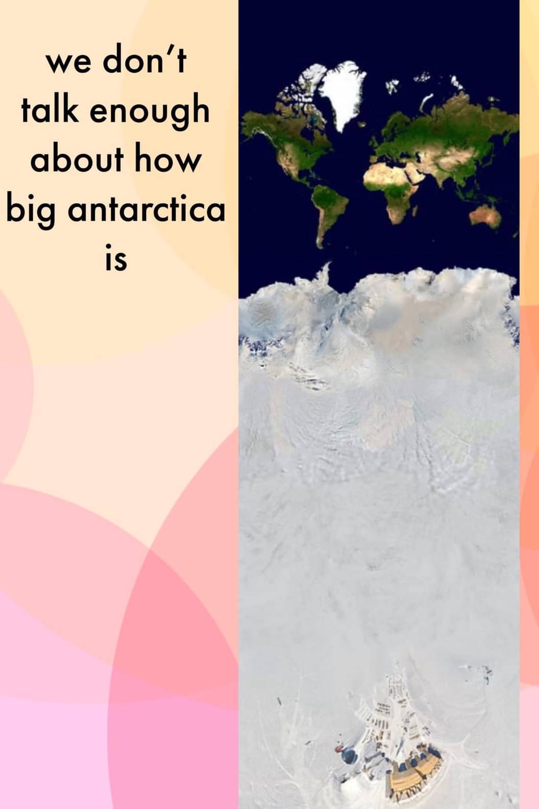
      According to this projection, it’s bigger than Africa

  • Daft_ish@lemmy.world
    link
    fedilink
    English
    arrow-up
    9
    ·
    2 years ago

    Can we talk about how big that structure is?

    • Obi@sopuli.xyz
      link
      fedilink
      English
      arrow-up
      7
      ·
      2 years ago

      About three times the size of Europe it seems, one hell of a building.

  • Landsharkgun@midwest.social
    link
    fedilink
    English
    arrow-up
    8
    ·
    2 years ago

    Ok, but that’s unironically a great map for a TTRPG campaign.

    I’m thinking Lovecraft. Plateau of Leng and all that. There’s just this huge, impassable land that goes south for what seems like forever. And…things…occasionally wander out of it.

  • A_Chilean_Cyborg@feddit.cl
    link
    fedilink
    English
    arrow-up
    6
    arrow-down
    3
    ·
    2 years ago

    My country holds a claim and permanent population to a portion of antartica.

    • AnUnusualRelic@lemmy.world
      link
      fedilink
      English
      arrow-up
      12
      arrow-down
      1
      ·
      2 years ago

      Many have “claims”. None are valid though.

      • A_Chilean_Cyborg@feddit.cl
        link
        fedilink
        English
        arrow-up
        4
        ·
        2 years ago

        Yeah but the permanent population is there, sakd claim precedes the treaty.

        • AnUnusualRelic@lemmy.world
          link
          fedilink
          English
          arrow-up
          1
          ·
          2 years ago

          You’re talking about penguins, right?

          • A_Chilean_Cyborg@feddit.cl
            link
            fedilink
            English
            arrow-up
            1
            ·
            2 years ago

            humans, in a town called “Villa las Estrellas”.

            • AnUnusualRelic@lemmy.world
              link
              fedilink
              English
              arrow-up
              1
              ·
              2 years ago

              It seems that treaty: 1959, town: 1984.

              • A_Chilean_Cyborg@feddit.cl
                link
                fedilink
                English
                arrow-up
                1
                ·
                2 years ago

                The claim is older, 1940’s iirc

      • 🇰 🌀 🇱 🇦 🇳 🇦 🇰 🇮 🏆@yiffit.net
        link
        fedilink
        English
        arrow-up
        3
        ·
        2 years ago

        How many flags are planted? No flag, no Antarctica. Those are the rules that I just made up.

        • Dasus@lemmy.world
          link
          fedilink
          English
          arrow-up
          2
          ·
          2 years ago

          Do you have a flag? — Eddie Izzard

      • DAMunzy@lemmy.dbzer0.com
        link
        fedilink
        English
        arrow-up
        2
        arrow-down
        1
        ·
        2 years ago

        All are equally valid

  • Optional@lemmy.world
    link
    fedilink
    English
    arrow-up
    3
    ·
    2 years ago

    No bears, tho.

  • milicent_bystandr@lemm.ee
    link
    fedilink
    English
    arrow-up
    2
    ·
    2 years ago

    I mean, show us the whole thing then!

  • slingstone@lemmy.world
    link
    fedilink
    English
    arrow-up
    2
    ·
    2 years ago

    It’s just the ice wall on the edge of the flat earth. Checkmate, globe-lovers!

    /s

  • Sam_Bass@lemmy.world
    link
    fedilink
    English
    arrow-up
    2
    ·
    2 years ago

    And getting smaller everyday

Science Memes@mander.xyz

science_memes@mander.xyz

Subscribe from Remote Instance

Create a post
You are not logged in. However you can subscribe from another Fediverse account, for example Lemmy or Mastodon. To do this, paste the following into the search field of your instance: [email protected]

Welcome to c/science_memes @ Mander.xyz!

A place for majestic STEMLORD peacocking, as well as memes about the realities of working in a lab.


Rules

  1. Don’t throw mud. Behave like an intellectual and remember the human.
  2. Keep it rooted (on topic).
  3. No spam.
  4. Infographics welcome, get schooled.

This is a science community. We use the Dawkins definition of meme.


Research Committee

  • [email protected]

Other Mander Communities

Science and Research

  • [email protected]
  • [email protected]
  • [email protected]

Biology and Life Sciences

  • [email protected]
  • [email protected]
  • [email protected]
  • [email protected]
  • [email protected]
  • [email protected]
  • [email protected]
  • [email protected]
  • [email protected]
  • [email protected]
  • [email protected]
  • [email protected]
  • [email protected]
  • [email protected]
  • [email protected]
  • [email protected]
  • [email protected]
  • [email protected]
  • [email protected]
  • [email protected]
  • [email protected]
  • [email protected]
  • [email protected]
  • [email protected]
  • !reptiles and [email protected]

Physical Sciences

  • [email protected]
  • [email protected]
  • [email protected]
  • [email protected]
  • [email protected]
  • [email protected]
  • [email protected]
  • [email protected]
  • [email protected]

Humanities and Social Sciences

  • [email protected]
  • [email protected]
  • [email protected]
  • [email protected]

Practical and Applied Sciences

  • !exercise-and [email protected]
  • [email protected]
  • !self [email protected]
  • [email protected]
  • [email protected]
  • [email protected]

Memes

  • [email protected]
  • [email protected]

Miscellaneous

  • [email protected]
  • [email protected]
Visibility: Public
globe

This community can be federated to other instances and be posted/commented in by their users.

  • 1.11K users / day
  • 5.89K users / week
  • 10.1K users / month
  • 20.9K users / 6 months
  • 2 local subscribers
  • 17.7K subscribers
  • 6.23K Posts
  • 154K Comments
  • Modlog
  • mods:
  • Salamander@mander.xyz
  • fossilesque@mander.xyz
  • SciBot@mander.xyz
  • fossilesque@lemmy.dbzer0.com
  • BE: 0.19.13
  • Modlog
  • Legal
  • Instances
  • Docs
  • Code
  • join-lemmy.org